Back to Weather

5-day forecast / Van Alstyne, TX

TodayMostly Sunny91° / 76° 2%
SundayShowers And Thunderstorms Likely84° / 66° 66%
MondayShowers And Thunderstorms78° / 63° 77%
TuesdayMostly Sunny85° / 71° 2%
WednesdaySunny92° / 77° 1%

Flood Watch in Effect for Van Alstyne as Heavy Rain Moves In

Van Alstyne weather, updated every four hours — local forecasts you can trust.

A severe Flood Watch is active for Van Alstyne, TX, as heavy rain and thunderstorms bring significant moisture tonight and Sunday. Temperatures will rise sharply by tomorrow.

Van Alstyne Newsroom

June 7, 20262 min read

National Weather Service radar for North Texas (KFWS)

Active Alerts and Current Conditions

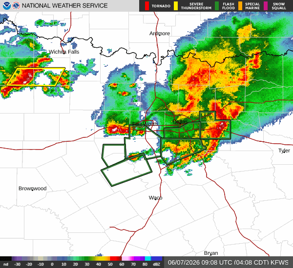
A severe Flood Watch is currently in effect for Van Alstyne, Texas. This alert was issued by the National Weather Service in Fort Worth and remains active through the early afternoon of tomorrow. Residents should remain vigilant as conditions are favorable for flooding.

It is currently Sunday overnight, and the area is experiencing rainy skies. The air temperature stands at 69F, with a feels-like temperature of 70F. Humidity is high at 89%, and the dew point is 65F. Winds are blowing from the south at 10 mph, with gusts reaching 11 mph.

Forecast for Today and Tomorrow

Rain is expected to continue through the overnight hours, with showers and thunderstorms likely. Cloudy skies will persist, and a low around 70F is anticipated. South winds will remain around 10 mph. There is a 70% chance of precipitation, with new rainfall amounts between a quarter and half of an inch possible.

Today, the high will reach near 80F, with a low near 68F. There is a 64% chance of precipitation, with heavy rain expected. Showers and thunderstorms are likely before 1pm, followed by a chance of showers and thunderstorms between 1pm and 4pm. Mostly cloudy skies will dominate the day. Heat index values may rise as high as 99. South winds will increase to 10 to 15 mph, with gusts as high as 25 mph. New rainfall amounts between a quarter and half of an inch are possible.

Tomorrow, conditions will shift significantly. The high will climb to near 89F, with a low near 74F. The chance of precipitation drops to just 2%, though thunderstorms are still possible. Partly cloudy skies will follow tonight, with a low around 75F. Heat index values may reach as high as 97. South winds will continue around 15 mph, with gusts up to 25 mph. Monday will bring mostly sunny skies and a high near 91F, with heat index values as high as 105.

Safety Reminder

With the active Flood Watch and heavy rain expected, please prioritize safety. Avoid driving through flooded roadways and stay informed about local weather updates. As temperatures rise later in the week, remember to hydrate frequently and limit midday exertion to avoid heat-related illnesses.

National Weather Service radar for North Texas (KFWS)

Sources

https://radar.weather.gov

https://api.weather.gov

https://open-meteo.com

Share

Van Alstyne Newsroom

Reporting from Van Alstyne and the surrounding area.

Related Stories

Weather

High Humidity and Heat Index Near 99 in Van Alstyne

Van Alstyne faces a humid start with a dew point of 73F. Today brings mostly sunny skies and a high near 91F, with heat index values reaching 99. Showers and thunderstorms are likely tomorrow.

Marlene OrtizJune 13, 20262 min read